Don't choose all the options at a time Use control and filter capabilities...
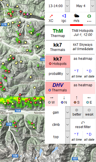 to customize your data view and functionality. Most resources are are used by TherMap and DHV Thermals.
Loading the TherMap Overlay may take some time.
to customize your data view and functionality. Most resources are are used by TherMap and DHV Thermals.
Loading the TherMap Overlay may take some time.
ThermiXC Help: DE | EN
ThermiXC is a non-commercial project to develop a XC planning tool for glider pilots. Use it free of charge and without registration!
The focal point is thermal data. The Thermix XC Planner
shows you the results of multiple thermal models and igc track evaluations.
You want to find new routes, leaving the highways? Check the TherMap Overlay, this model
uses topografical data and is independent of igc tracks! To find the well-known thermals at popular
sites or XC routes, refer to the kk7 model, including the skyways.
In order to find best thermals, depending on the wind direction, use the DHV model.
For details, see thermals section below.
Evaluate your routes, tasks and tracks.
Drop a route, task, or track file on ThermiXC, check where you might
have missed the best route.
Compare historical thermal data with your route or track line, and check out other tracks.
Read more ...
No user data is collected, no cookies are transfered to our server. But ...
we collect anonymised statistics about ThermiXC usage count, time and the XC functions called.
We use this data for development purposes only, nobody else will see this data.
Specific function require to store some (anonymized) data on our server, e.g. short-URL or QR-code data.
Be aware that ThermiXC is based on Google API products, which collect information about their users.
For details check our information privacy policy (DE:"Datenschutz").
We recommend to use Firefox or Chrome, and to...
use the most recent browser release. Internet Explorer and Safari should work at least 95%.
Keep Javascript enabled for ThermiXC! We also recommend ...
to allow cookies for our site! We do not use cookies, but a browser storage local to your PC
to support history, personal settings, "undo" functionality etc., which usually depends on the same browser settings as cookies.
Do not disable the Javascript Popups!
If ThermiXC is very slow, crashed, or misbehaved - for example after ...
a release or data update - follow these steps as long as the problem remains:
Thanks to our contributors for providing thermal, site and airspace data free or charge. Data is provided and displayed without warranty.
For more, read the thermal sectionThermal waypoints are available from several thermal quality models and igc evaluation algorithms....
Play with the zoom level! Level of detail of thermal data and some other tool functions depend on...
the zoom level. For details, see thermals section below.
Don't choose all the options at a time Use control and filter capabilities...
to customize your data view and functionality. Most resources are are used by TherMap and DHV Thermals.
Loading the TherMap Overlay may take some time.
"Mouse over" the control panel and hold on 1 or 2 seconds ...
to display a short "tool tip" about what happens if you click this panel field.
1-click-mode: if the XC Tab option "Create route" and/or "Create markers" is on and you click the map,
NO info window will pop up, but a route waypoint or a marker will be created immediately after clicking.
Click on the map terrain, or any marker, waypoint or airspace,
to open an "info window" for this location, or to create a marker or waypoint immediately (depending on your settings)...
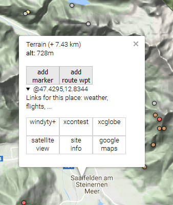
The info window shows coordinates, altitude, distance to the most recently opened info window (marked with a blue marker on a PC),
and specific information and functions.
For example, search for xcontest flights near to this point.
Check airspaces when planning a route - but be aware...
that airspace information displayed in ThermiXC is for information only, and
may be not accurate or out of date. Data is provided for non-commercial use only, free of charge and without warranty by
© John Leibacher, soaringweb.org,
© DHV e.V.,
© OpenAIP.net,
© airspace.xcontest.org,
.
Some data used comes from openAIP or soaringweb.org. Visit openAIP.net or soaringweb.org and contribute to better aviation data,
free for everyone to use and share.
Always consult official soures about active airspaces and restrictions before you start your flight!
Competiton score of your flight will be shown in the XC Tab.
The flight plan summary below the score shows distances, final approach, airtime and speed.
Modify and evaluate your route...
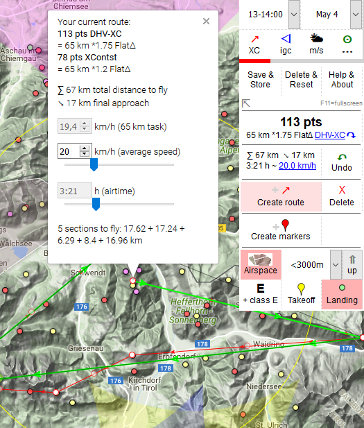
Click on the score to switch your scoring rule (DHV, XContest,..) or to turn it OFF.
Click here to modify speed or airtime.
You might save your plan as URL or file,
multiple file formats are supported.
Share the URL or file with your friends.
If you save your plan as URL, ThermiXC will reload with this URL.
Don't forget to save this URL after that as bookmark or to the filesystem!
To transfer your markers and route to your GPS, save the plan as file.
The flight plan: a „plan“ has a name, contains your markers and the current route, and the view date and time.Save your plan! Click on "XC Tab": "Save & Share"...
Synchronize your bookmarks with your PC, tablet and smartphone, ...
use the standard capabilities of your browser. Plan your flights on the PC, review or modify the plan on your smartphone
later on your holiday trip, and store waypoints to your XC App like XC-Track. No need to copy "gpx" or "wpt" files
from the PC to your smartphone.
drop
igc, gpx, wpt, cup, tsk (SKYTRAXX 3.0), xctsk (XCTrack),
txt
or kml-files
on the map, or select the igc Tab and click "Add track or waypoint files"
to draw tracklines, routes or waypoints contained in those files.
You might also drop URLs (from your browser adress field, bookmarks or links) of
ThermiXC plans, windy.com or here.com
on the map.
Note: Filename suffix is important!
The igc Tab shows the list of open files and URLs:
filename : evaluate the track, show info about this file (click on filename)
Analyze tasks, tracks and routes ...
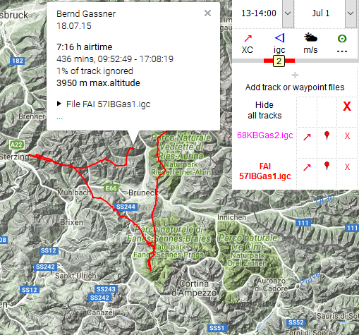
↗: use track as template to create or extend your route
 : add/remove waypoints contained in this files to/from your marker set
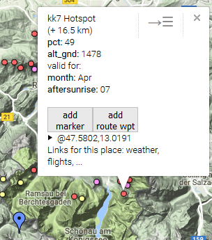
In this case, an info window contains two control fields at the top right corner:
the first one (→☰) closes all info windows
and reopens the menu most recently used. The second (x) just closes this info window.
Or click on the right screen border, or swipe from the right to reopen the last menu used.
Small screen? Menus and info windows don't fit well...
 on the screen: if you open an info window on a small screen device, the menu will disapear (other than on your PC).
You might also swipe the menu to the right to close it temporarily.
on the screen: if you open an info window on a small screen device, the menu will disapear (other than on your PC).
You might also swipe the menu to the right to close it temporarily.
Create precise waypoints on a touchscreen...
 Instead of clicking directly on the map, move the map underneath the pin of the green marker, and click the marker's pin.
The new point will be created exactly at the marker's pin.
Instead of clicking directly on the map, move the map underneath the pin of the green marker, and click the marker's pin.
The new point will be created exactly at the marker's pin.
About thermal data
TherMap: thermal quality computations based on date, time, heat accumulation, slope orientation and inclination. Weather data and valley wind systems are not included.
I found TherMap especially useful for new routes, which follow no highways, since no igc data is used!
But: be aware that this overlay is based on static, topografic data. It really helps to read a map, but
does not add any information. So do not stop thinking if you find a red spot on the map, just look at
it like a sunny slope in front of you on a xc flight.
TherMap in ThermiXC is currently only available for the Alps, Apennin and Pyrenees.
Download: © Dr.B.Sigrist, aerodrome-gruyere.ch
KK7 Hotspots are based on igc tracks, like DHV-XC. Evaluations focus on probabilty, date and time,
and use the same database known from the "skyways"!
Data are availabe for many regions, including some flatland spots.
Download: © Michael von Känel, thermal.kk7.ch
DHV XC thermals are also based on igc tracks, and can be filtered by wind direction and thermal strength, time and date.
Data are availabe for many regions, including some flatland spots.
Download: © DHV e.V.
ThermiXC file formats: IGC, ThermiXC bookmark (QR and URL), GPX, XCTSK (QR and file), TSK, KML, TXT, WPT, CUP, LKT,
to support
Garmin,
Skytraxx,
XCTrack,
Syride,
SPOT livetracking feeds (old style URL!),
Naviter,
SeeYou,
XCSoar,
LK8000,
and others. More formats may follow ...
Bernd Gassner, © 2014,2024 -- Send Feedback
Have fun!