Level of detail of thermal data and some other tool functions depend on the zoom level. If you see only very few or too many thermals, try to toggle heatmap and waypoints view, or to adjust filter conditions.
Be careful with DHV-XC thermals, set filter conditions appropriate when switching between zoom levels. For details, see thermals section below.

Use the control panels to customize view and functionality. Loading the Thermap Overlay may take some time.
... and hold on 1 or 2 seconds, to display a short "tool tip" about what happens if you click this panel field.
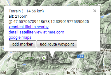
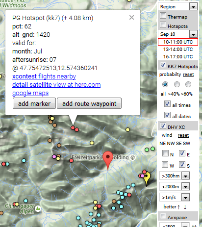
... to open an "info window" for this location.
The info window shows coordinates, altitude, distance to the most recently opened info window, and specific informations and functions.
For example, search for xcontest flights near to this point!
Note: if the "Create route" and/or "Create markers" checkbox is checked,
NO info window will pop up, but a route waypoint or a marker will be created immediately after clicking!
Note: if you click an airspace, you can NOT create a waypoint there, you will see airspace data instead (i.e. class, floor, deiling).
If you really want to create a point there,
simply disable the airspace overlay (uncheck the airspace control box, see right control panel)
Click on the map, and then click the "add marker" or "add route waypoint" button of the info window.
Or check the "Create route" and/or "Create marker" box before, to suppress an info window and create the point immediately.
Note: a marker is a waypoint independent of the route, for example to mark a takeoff or landing point, an alternative turnpoint or any other point of interest. Rename the marker as appropriate!
... when planning a route - but be aware that airspace information displayed in Thermixc is for information only, and may be not accurate or out of date. Data is provided free of charge and without warranty by © John Leibacher, soaringweb.org.
Always consult official soures about active airspaces and restrictions before you start your flight!
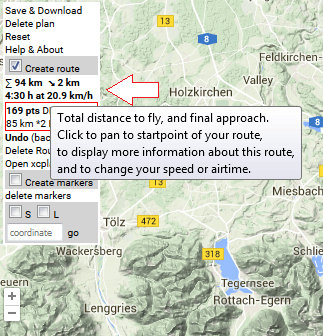
- Route information summary shows distances, speed and time ... click the panel field to see details, and modify speed or airtime
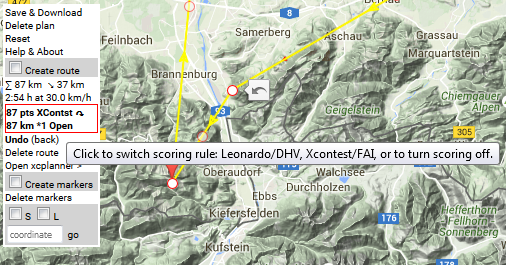
- Competition score is computed ... click here to switch your scoring rule (DHV, XContest,..) or to turn it OFF!
- drag the mid-point of an edge with your mouse to create a new turnpoint
- click on a vertex to remove the vertex
- use the "Undo (back)" function to undo most recent route modifications and go back to previous versions of your route
Click "Save & Download".
If you save your plan as URL, Thermixc will reload with this URL - don't forget to save this URL as bookmark or to the filesystem!
Note: a „plan“ has a name, contains your markers and the current route, and the view date and time.
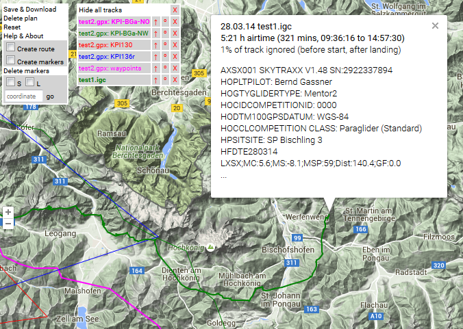
Drop ".igc", ".gpx", „.wpt“ or ".kml"-files on the map to draw tracklines, routes or waypoints contained in those files.
Note: Filename suffix is important!
Dropping bookmarks or URLs created for Thermixc plans, windyty.com or here.com satellite pictures is supported.
A list of "everything" you've dropped will pop up, including a new control panel:
- filename : evaluate the track, show info about this file (click on filename)
- ° : add/remove waypoints contained in this files to/from your marker set
- ↑ : use track as template to create or extend your route
... and - as you already know - an info window containing information about the marker will pop up. Note how colors are used:
- big drop-shaped red markers are your "own" markers, created manually or imported from .kml-, .wpt- or .gpx files
- small drop-shaped yellow markers are well-known takeoff spots (check the "S" takeoff/start-checkbox on the left control panel)
- small, green, round slices are well-known landing fields (check the "L" landing-checkbox on the left control panel)
- KK7-PG-Hotspots and
- Thermap Hotspots ,
both show thermal quality by time and date (+KK7: probabilty):
- pink are best, „hottest“ thermal spots,
- red is a good, „hot“ thermal spot
- yellow is a reasonable, „warm“ thermal spot:
- DHV-XC thermals
show thermal quality by wind direction, time and date:
- grey = west wind,“clouded“
- blue, light blue = north, and east wind, „cold, dry“
- brown = south, „warm“
Play with thermal filter settings and you will get used to the colors soon!
Thermap: thermal quality computations based on date, time, heat accumulation, slope orientation and inclination. Weather data and valley wind systems are not included.
I found Thermap especially useful for new routes, which follow no highways, since no igc data is used!
But: be aware that this overlay is based on static, topografic data. It really helps to read a map, but
does not add any information. So do not stop thinking if you find a red spot on the map, just look at
it like a sunny slope in front of you on a xc flight.
Thermap in Thermixc is currently only available for the Alps, Apennin and Pyrenees.
Download: © Dr.B.Sigrist, aerodrome-gruyere.ch
KK7 Hotspots are based on igc tracks, like DHV-XC. Evaluations focus on probabilty, date and time, and use the same database known from the "skyways"!
Data are availabe for many regions, including some flatland spots.
If you see no data, first check your filter conditions.
Then toggle "heatmap" and "waypoint" view.
If you still see nothing, check the time wildcard (*T), or try date wildcard (*D). If you see nothing, then we have no data there.
Download: © Michael von Känel, thermal.kk7.ch
DHV XC thermals are also based on igc tracks, and can be filtered by wind direction and thermal strength, time and date.
Data are availabe for many regions, including some flatland spots.
Be careful zooming in and out without proper filter conditions, especially when *D wildcard is checked (ignores date, and returns a lot of data). Currently there are 600000 thermals avaliable! In the case data are not loaded properly, change the filter conditions and temporarily disable DHV XC thermals and Airspaces. Note that clicking on DHV-XC thermal waypoints only works at higher zoom levels for perfomance reasons.
If you see no data, first check your filter conditions, then toggle "heatmap" and "waypoint" view. See description for KK7 Hotspots above.
Download: © DHV e.V.